The multidisciplinary panel “ comprising geologists, hydrogeologists, engineers, biodiversity and economics experts along with officials from Forest, Water Resources, Agriculture, Revenue and Town and Country Planning departments “ conducted two years of field investigations using drone-assisted surveys, remote sensing, laboratory testing and geospatial analysis.
The report, based on studies conducted in 2024 and 2025, examined representative landslide locations and updated risk assessments to develop a scientific framework for future landslide management.
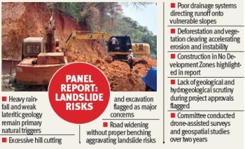
Natural factors remain key trigger
The committee found that heavy rainfall, including extreme precipitation events, and weak geological formations are the primary causes of landslides in Goa, particularly in areas dominated by lateritic soils that become highly unstable after saturation.
Human activities intensifying risk
It observed that excessive slope cutting without proper benching, especially during road construction and widening projects, has aggravated instability.
Roadside cutting on steep hillsides emerged as a major concern, with inspections revealing uprooted trees flowing downslope after failures, accelerating erosion and deforestation.
Deforestation and clearing of native vegetation, including hill slopes used for cash crop management such as cashew cultivation, poor stormwater management and drainage systems directing runoff onto slopes, construction in No Development Zones (NDZs) despite known vulnerability and lack of involvement of geologists and hydrogeologists during project approvals and technical scrutiny are some of the key points highlighted by the panel.
The committee cited examples like Loutolim, where road widening led to embankment failure, and Verna, where inadequate drainage channelled water onto unstable slopes. Further, urban pockets including Fatorda and Betim were specifically highlighted as areas where development pressure has amplified landslide risks.